The silver fern is prevalent in New Zealand and can grow to heights of 30 feet. Its unfurling frond, shown here, is one of the national symbols of the country.
New Zealand is a nation in the southwest Pacific comprised of two main islands, known as the North and South Islands. It is a member of the British Commonwealth.
Fast Facts:
Languages: English (The New Zealand accent is similar to the Australian accent with a few unique words), and to a lesser extent the Maori language. The Maori word “kia ora” is used widely as a greeting.
Currency: New Zealand dollar. As of December 2016, the exchange rate is around 1 USD = 1.43 NZD.
Getting in: US citizens can enter New Zealand without a visa and can stay for up to 90 days.
Getting Around: There are a few good ways to get around the islands. Long distance buses run between many cities, and buying a bus pass valid for a certain number of trips may not be a bad idea. If your trip is short, car and campervan relocations are possible for free, but usually only from south to north. You can check Transfercar, imoova.com, or Jucy for availability. The major downside to relocations is that they are usually only for a week or less. Other than relocations, renting a car or campervan in New Zealand can be quite expensive. A surprisingly good way to get around in New Zealand is by hitchhiking; New Zealand is one of the safest countries in the world, and the people are quite friendly so you should have no problem getting picked up if you are in a good spot. Last but not least, flying can be a great way to cover long distances quickly, as New Zealand has a great network of domestic airports and flights are reasonably priced. The only way (besides flying) to get between the islands is by ferry from Wellington to Picton.
When to visit: Since New Zealand is in the southern hemisphere, their seasons are reversed from those of North America, Europe, and Asia. The warm season from November to March is probably the most comfortable time to visit. Also, during this time, the roads are open more often and avalanche danger is not much of an issue in the mountains. Keep in mind that peak travel time in New Zealand is during the school summer holidays in mid December to early February, and during this time the ferry running between the islands, as well as the most popular tourist activities (e.g. Hobbiton, Milford Sound cruises, and bungee jumping) will need to be reserved a few days in advance. Skiers may wish to visit in the winter, which runs from June to September.
How to visit: United Airlines and Alaska Airlines miles are both good options- they will cost you 80,000 round-trip. American Airlines also charges 80,000 miles for a round-trip ticket, however availability is more limited since routing rules are more restrictive. If you are looking to pay for a flight, New Zealand is one of the most expensive places in the world to fly to from North America, and you’ll likely be paying over $1000 round-trip.
Highlights of New Zealand:
Interestingly enough, New Zealand was uninhabited until the 13th century when the Maori people arrived from Polynesia. The Maori culture is still alive in New Zealand today, with a portion of the population speaking the language at home. In the 1600’s, the Europeans started arriving and today most of the population of the country is of European ancestry.
Originally, New Zealand was only home to birds, bats, and marine mammals. Early European settlers brought land mammals to the islands, which unfortunately changed the ecosystem and caused many of the native birds (especially the flightless ones) to become endangered or extinct. Sadly, the Kiwi bird population has been decimated and it is very rare to see one today, especially in the north.
I’ll begin by covering the North Island of New Zealand, which is smaller in size but houses about three quarters of the population. The North Island also has more Maori than the South Island and much of the geothermal activity in the country.
The largest city by far in all of New Zealand is Auckland, on the north side of the North Island. It is a vibrant international city and a hub for the Southwest Pacific. There are many immigrants from all over Asia as well as the Pacific islands living in the city. It is culturally different from the rest of New Zealand, and according to many New Zealanders (or “Kiwis” as they call themselves), by only going to Auckland one would not get a full New Zealand experience. However, it is still well worth visiting, especially considering the great variety of good foods you can find in the city. (Tip: do not leave Auckland without trying the Indian food there- it is absolutely amazing!)
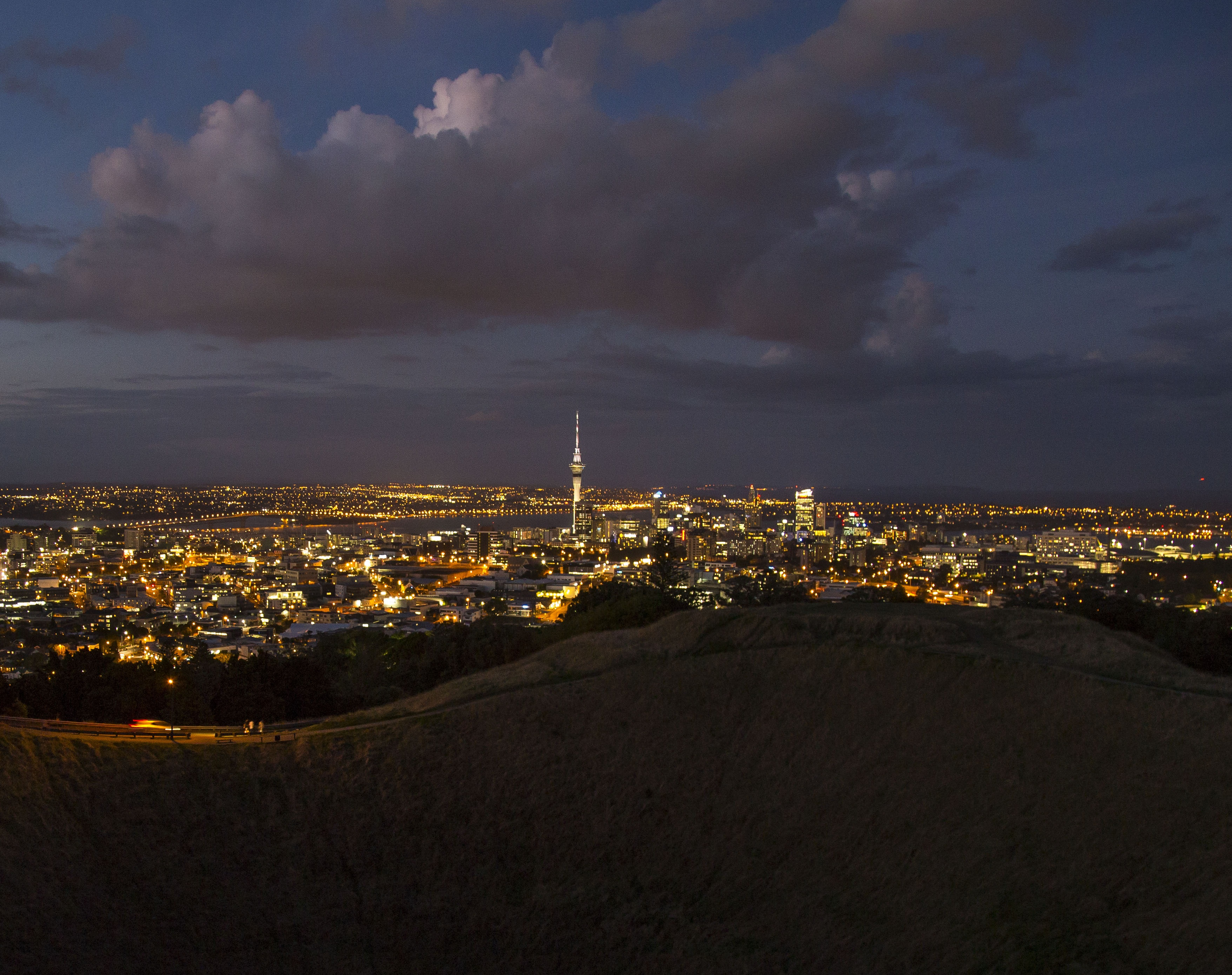
Auckland is home to the Sky Tower, the tallest building in the Southern Hemisphere at 1076 feet tall. For a fee, you can visit the observation deck and look upon the city. Other good views of Auckland and the surrounding areas can be seen from Mt. Eden and One Tree Hill, which are southeast of the city center. The rock band U2 named one of their albums after One Tree Hill, which used to have a lone tree at the summit that was heavily damaged by protesters and then removed in October 2000. It is worth noting that out of the four international airports in New Zealand (Auckland, Wellington, Christchurch, and Queenstown), the Auckland airport is the largest and most common entry point to the country. Public transportation can be taken into the city center from the airport for 10-20 NZD, depending on if you take the more expensive but direct Airbus or take another bus and then transfer to get to the city center.
Only a short ferry ride away from central Auckland lies Waiheke Island. Waiheke Island is best known for its wineries but also has some great beaches and walking trails. It is much more laid back than Auckland and makes for a great escape from the hustle and bustle of the city. After getting off the ferry at the west end of the island, there are many scenic walking trails you can take to reach arguably the best beach on the island (Oneroa) in under an hour.
A few hours north of Auckland by car are the Bay of Islands and the tourist town of Paihia. From Paihia there are a variety of moderately expensive tours you can take to explore the bay, however if you want to get off the beaten path a bit you can negotiate passage with the tour boats to visit just a single island for much less. Around Paihia it is also possible to visit some Maori cultural sites.
The Coromandel Peninsula, east of Auckland, also has some scenic beaches. Among them, Hot Water Beach is probably the best known. Hot Water Beach is unusual in that you can dig your own hot spring in the sand during low tide, and then enjoy the warm spring water on the beach! It is a nice alternative to the cold ocean water. As the Coromandel can get quite crowded during the New Zealand summer holidays (Dec-early Feb), it may be better to visit Kawhia on the west coast instead, which also has a beach with hot springs at low tide.
South of the Coromandel and southeast of Auckland a few hours lies the Anderson Family Farm, better known to the rest of the world as the site where Hobbiton was filmed in J. R. R. Tolkien’s Lord of the Rings and The Hobbit. Tours of the farm are decently expensive, but I thought the experience was worth the high price. Tours need to be reserved a few days in advance, so keep this in mind when planning your trip. The drinks served on the tour can be found at Good George Brewing in Hamilton, which may be a good reason to spend a night in Hamilton if it is on your route.
Near the center of the North Island are Rotorua and Taupo. Both of these cities are located on the shores of large lakes (Lake Taupo is the largest lake in New Zealand by surface area) and have an impressive amount of geothermal activity. Rotorua is one of the larger cities on the North Island and is also a tourist hub. There are lots of things to do in the area, most of which cost a bit of money, including the Kiwi sport of zorbing and numerous thermal attractions and springs. Probably the most famous geothermal site in Rotorua is Te Puia, which contains a geyser and Maori exhibition, among other sights. The best kept secret of Rotorua is that there are actually quite a few beautiful hot springs, sulpheric steam vents, and bubbling mud pools which you can see and experience for absolutely free at Kuirau Park near the city center. Taupo is a bit less high profile than Rotorua and offers stunning lake views as well as a neat hot stream that you can relax in for free. Taupo also has one of the only free campsites I was able to find in New Zealand, Reid’s Farm Recreation Reserve.
About an hour south of Taupo is Tongariro National Park, where you can find Mt. Ngauruhoe, filming location for Mt. Doom in Lord of the Rings. If you have the time, I would recommend hiking the Tongariro Alpine Crossing, which takes about 5-9 hours depending on your pace. The crossing goes through otherworldly volcanic scenery including craters, pools, and steaming vents. It also gives great views of several volcanoes and the surrounding countryside. (Spoiler alert: unlike Mt. Doom in Lord of the Rings, Ngauruhoe does not actually contain lava. If you attempt to summit it on the side path from the Tongariro Crossing, do not expect to be able to destroy your ring in the fires of Mordor.)
The southernmost city on the North Island is Wellington, which is also the capital of New Zealand. Wellington is known for its coffee, beaches, and beautiful cityscape. The city is a favorite among Kiwis, and has a bit of a hipster feel. It is also home to the national museum of New Zealand Te Papa, which is free to visit, as well as the Weta Cave, which provides insight into the film industry of New Zealand. A good view of Wellington can be found by summiting Mt. Victoria.
Ferries from Wellington to the South Island depart several times a day and usually need to be reserved a few days in advance. Two companies, Bluebridge and Interislander, operate the route.
The South Island of New Zealand is larger and more sparsely populated than the North Island. It has plenty of remote areas which can only be accessed by foot or by sea. A spine of mountains known as the Southern Alps runs down the western part of the island and the southwest coast has numerous fjords.
Christchurch, near the east coast, is the largest city on the South Island. Prior to September 2010, Christchurch was a bustling metropolis with a beautiful city center. According to many Kiwis, it was the best place to live in the country. Then starting in September 2010, a series of devastating earthquakes shook the city and much of it was badly damaged or crumbled to the ground. Unfortunately, it is not the same today, as many families are still living in temporary housing. Work is being done to rebuild the city from the ground up, however many of the Victorian Era buildings are being replaced with modern architecture so the look is quite different and the vibrant city scene has still not fully returned. Nevertheless, Christchurch is still the hub for the South Island. To learn more about the earthquakes, you can visit Quake City in central Christchurch.
Christchurch has the second largest airport in New Zealand, and it is quite easy and quick to take the city bus from the airport into the center. (Tip: if you walk 500 feet out of the airport to the bus stop next to the Antarctic Center, you will only pay the regular bus fare, around 3 NZD, rather than the excessive airport fare.)
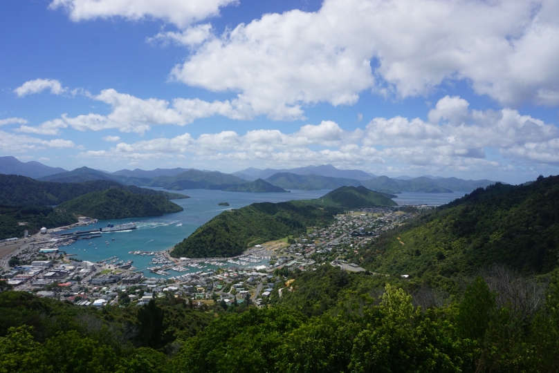
North of Christchurch a few hours is the town of Kaikoura, known for its steep cliffs which drop off into the ocean as well as its seal colonies and whales. North of Kaikoura is the wine region of Blenheim and the Marlborough Sounds. The Marlborough Sounds are a series of waterways with hilly, forested peninsulas which jut out into the ocean. They are a place where many Kiwis have “baches”, or retreat cabins, and the pace of life is slow. The largest town on the Sounds is Picton, where the ferries to the North Island depart from.
West of Picton is the city of Nelson, known for its art and hippie culture. Many of the Maori on the South Island live in the Nelson area. Northwestward up the coast from Nelson is the Golden Bay area, which has great beaches and the self-proclaimed clearest spring in the world, Te Waikoropupu. Also in the area is Abel Tasman National Park with its scenic coastline which is popular with kayakers.
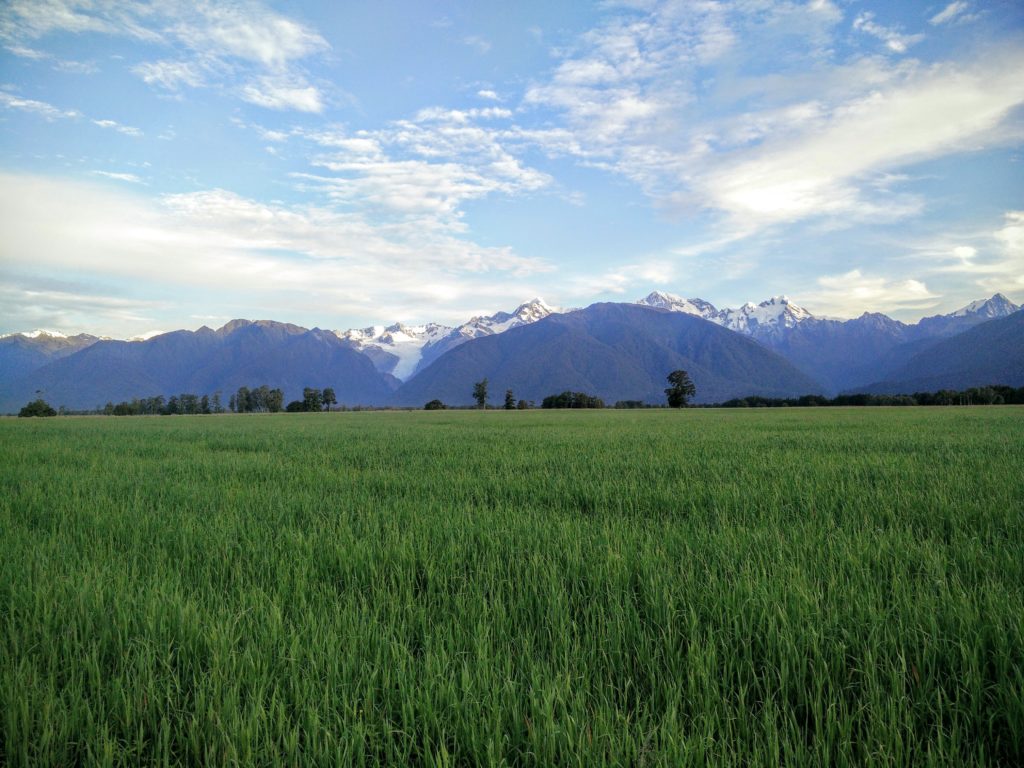
The pristine west coast of the South Island consists of vast stretches of cliffs, beach, and temperate rain forest dotted by old mining towns and small villages. The Southern Alps can be seen from much of the west coast. I would recommend visiting the Pancake Rocks near Punakaiki, as well as the Franz Josef Glacier and Fox Glacier regions. Franz Josef is the more developed of the two glacier regions, but Fox Glacier is the larger glacier. Both glaciers are a brief walk away from their respective parking lots. Near the glaciers there are various bird sanctuaries as well as some of the best views of the Southern Alps. At night some areas of the rain forest come alive with glow worms.
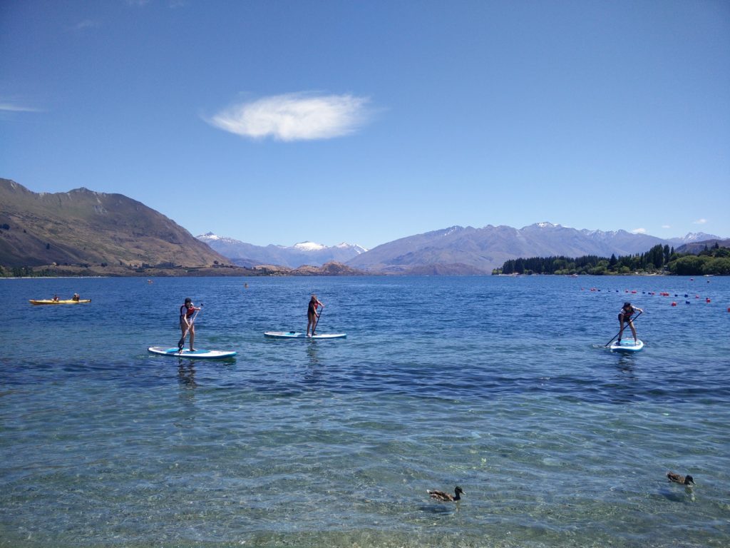
South of the glacier regions, the main road leaves the coast and crosses through the Southern Alps, reaching the town of Wanaka on the drier east side of the range. Wanaka’s main business district is located along the south shore of Lake Wanaka, which also has a beach and a myriad of water sport activities in the summer months.
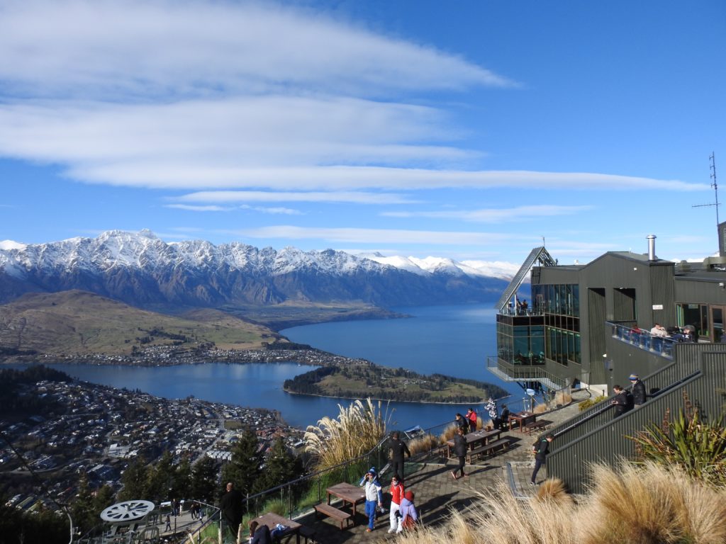
Another hour south of Wanaka is Queenstown, known as the adventure capital of the world. Queenstown is on the shores of Lake Wakatipu, the longest lake in New Zealand, and is surrounded by forested mountains. It has a booming tourism industry centered around adventure sports: bungee jumping, skydiving, and river rafting are among the most popular in the summer and skiing is big in the winter. A gondola goes up an adjacent mountain for views of the surrounding area. Since Queenstown is packed with tourists, it has a thriving nightlife for a town of its size and the bars and clubs can get crazy. Visiting Fergburger, a local burger joint, can also be quite the experience since the lines are out the door and you may have to wait as much as an hour to get your burger. Some claim that it has the best burgers in the world; I personally thought their original burger tasted a lot like a typical hamburger with some Montreal Steak Seasoning added to it.
If you would prefer to get away from the craziness of Queenstown, an alternative might be to head to Arrowtown, a historic gold mining town nearby. Another option would be to make your way up Lake Wakatipu to Glenorchy and Paradise, where many Lord of the Rings scenes were filmed including portions of Lothlórien.
West of Queenstown, on the southwest coast of New Zealand, is Fiordland National Park, a vast and remote area with (you guessed it!) spectacular fjords lining the coast. Much of the park is inaccessible except by air, sea, or foot, and many of the country’s well known multi-day walking tracks are in the area. The only fjord which is accessible by car is Milford Sound, which is also the most visited tourist attraction in all of New Zealand. The road to Milford Sound is a wonder in itself, winding along cliffs and through a one-way tunnel which changes direction every 5 or 10 minutes. Short cruises around the fjord run frequently throughout the day, and provide a good opportunity to see the two large, cascading waterfalls which empty into the fjord.
To the south and east of Queenstown, the coast is a bit less rugged and more accessible. This is probably the best area of New Zealand for encountering penguins. The cities Invercargill and Dunedin are in the area, and of the two Dunedin is likely the more interesting to explore. Unlike Christchurch, Dunedin still retains its Victorian Era buildings and European charm, and has a distinctly Scottish heritage. It is a university town, with a large portion of its population in the form of students. Dunedin is also home to the Speight’s brewery, which produces a plethora of beers that are extremely popular across the South Island.
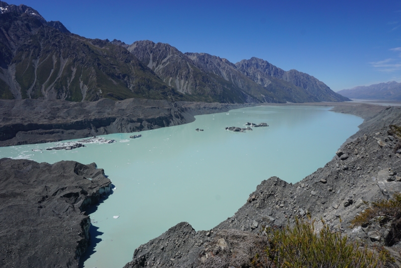
Moving up the center of the island from Queenstown, you’ll encounter Mount Cook National Park, aptly named after the highest peak in New Zealand. However, the park contains an entire range of spectacular mountains and glaciers, and it is worth setting aside ample time to explore. A good home base might be the White Horse Hill campground, which is situated just below the icy southeast face of Mt. Sefton and reachable by road.
- Mt. Cook, the highest point in New Zealand
- Tasman Glacier
Lake Tekapo is only a short drive up the road from Mount Cook National Park and provides a nice spot to relax and wind down from the excitement of the region. There is a small town and a private campground on the shores of the lake, as well as a water park and numerous opportunities for water sports if your heart so desires. The Mount John Observatory is only a short walk or drive up nearby Mt. John, and gives a great view of the surrounding dry landscape during the day or of the stars at night. From Lake Tekapo it is easy to return to Christchurch by driving eastward out of the mountains and then northeastward through agricultural areas and the municipality of Ashburton.
Remember that both of New Zealand’s islands are very large and that the places described here are only a fraction of what the country has to offer. Still, I hope that this glimpse can provide you with some inspiration to experience the country’s beautiful scenery and culture on your own!


